2/14/2010

Iquique – January 2010

This summer’s vacation was a bit short. A had been head of pathology for less that a month with no backup and couldn’t take her full vacation so we decided to go north for a week – to Iquique; 1000 miles from Santiago and  200 miles south of the Peruvian border.

Why Iquique?  Mainly because we had never been there, or anywhere else in Chile’s norte grande, and needed a restful week.   And we knew it wouldn’t rain; it is in the driest region on earth. Average annual precipitation is .5 mm (.02 inches), but temperatures are moderate, the average high in the warmest month is 77°, in the coldest, 65°.
Iquique was founded in 1788 as a port for the salitre (sodium nitrate) mines in the Atacama Desert, then a part of Peru.  After the 1879 War of the Pacific, in which Chile defeated Peru and Bolivia, it became Chilean, and in the following 50 years brought great wealth to Chile as (mainly) foreign companies extracted salitre and sold it around the world as a source of nitrogen for fertilizers and munitions.  After the 1940s synthetic nitrogen largely eliminated the market for salitre, leaving Iquique dependant on fishing and fish meal processing, and on supplying copper and other mines in the Atacama.
Iquique’s isolated location on a narrow strip of sand between the Atacama and the Pacific Ocean, nicely captured in this photo, means that everything the city needs (except water, desalinated from the sea) must come in by truck, ship, or like us, by air in a three hour flight from Santiago.   To the east is the Atacama Desert.  Going south it’s 230 miles to Antofagasta, the next city; to the north, Arica is 200 miles.  
Click on photos to enlarge


Landing and on the taxi ride in from the airport (20+ minutes) the absence of vegetation is striking.  There is literally nothing green, alive, growing out of the earth, except where planted and watered by people.  Once in the city, there is more vegetation, but it is hardly verdant – landscaping is not one of the city’s strengths.


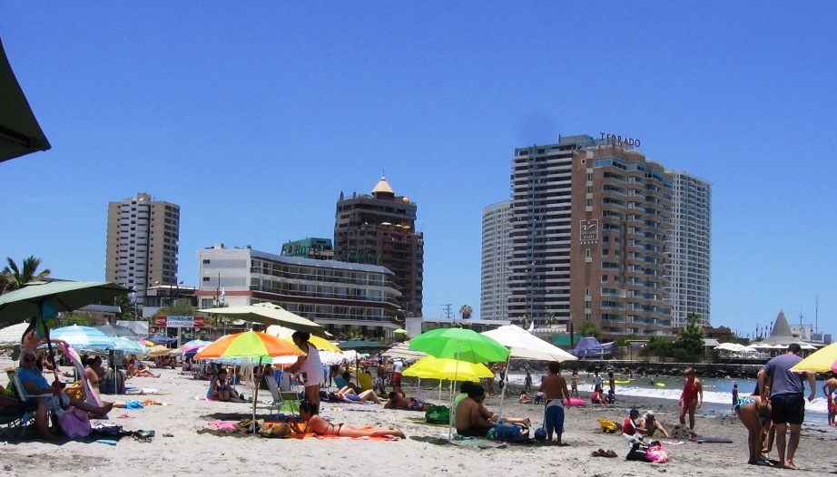
Our hotel, south of the city center and a block from the beach, was pleasant if unremarkable.


But it had an ocean view….  more or less


The old city center, now including a pedestrian mall leading to the plaza, is full of old wood-frame buildings dating to the 19th and early 20th century.

It includes a good small regional museum that covers Iquique’s culture history from the prehistoric Chinchorro people (and their mummies) to the salitre mining period and the region's indigenous Aymara people.


The Chinchorro mummies, dating to as early as 6000 BP, are the world’s oldest.


At the end of the mall is the Plaza, with the Club Croata and the Casino EspaƱola at the far corner.  The clubs were established by foreign mine owners and executives in the late 19th century.  There is also a British Union Club.


We had almuerzo in the ornate Casino EspaƱola,

       …followed by a little rest by the fountain.


And there is the beach.


*******

One of the highlights of a trip to Iquique is a tour of the salitre  offices and other sights of the Atacama.  From Iquique we climbed abruptly 1700+ feet or up to Alto Hospicio, Iquique’s low rent suburb, and on through the coast range at at altitude of 3800 feet, then down into the dry lake bed where the salitre was mined. 


Our first stop was at the Officina Santa Laura, just east of Humberstone on the map.  The mines were called “offices” because the first mining was done by independents who blasted through the hard caliche to mine the softer deposits below, which they brought to the offices for sale.  Later the offices became headquarters for mining and processing the sodium nitrate.


Officina Santa Laura, now with Humberstone, a UNESCO World Heritage Site, described as:


Humberstone and Santa Laura works contain over 200 former saltpeter works where workers from Chile, Peru and Bolivia lived in company towns and forged a distinctive communal
pampinos culture. That culture is manifest in their rich language, creativity, and solidarity, and, above all, in their pioneering struggle for social justice, which had a profound impact on social history. Situated in the remote desert Pampa, one of the driest deserts on earth, thousands of pampinos lived and worked in this hostile environment, for over 60 years, from 1880, to process the largest deposit of saltpeter in the world, producing the fertilizer sodium nitrate that was to transform agricultural lands in North and South America, and in Europe, and produce great wealth for Chile. Because of the vulnerability of the structures and because of the impact of a recent earthquake, the site was also placed on the List of World Heritage in Danger, to help mobilize resources for its conservation.

The salitre processing plant

...and administrators’ living quarters.


A short distance further on is Humberstone, here showing the company town plaza.


The workers quarters.


The swimming pool.


The theater.


From Humberstone we turned south on the Pan American Highway, passed through Pozo Almonte (which in spite of being one of the driest places on earth, has some truck gardening, based on underground water) and on through the southern part of the Reserva Nacional Pampa del Tamaruga.  The Tamarugo tree (Prosopis tamarugo) was once plentiful in this area, subsisting on subsurface water reached by its tap roots, but was almost completely eradicated for fuel during the nitrates boom.  (How did it manage to reproduce and grow long enough roots to reach water?)  Groves were reestablished by planting and irrigation in the 60s and 70s.


Tamarugo plantation,  FAO photo


Pampa de Tamaruga, tree plantations are the dark line on the horizon.

Our tour continued south to Cerro Pintados, site of a group of geoglyphs; figures etched into the desert pavement by clearing away the weathered surface gravel and exposing the lighter colored surface below.  Similar glyphs, like the famous Nazca lines, exist in numerous locations in northern Chile and southern Peru.  They were created by native people between about 300 BC and the early historic period.


The geoglyphs with the deserted Cerro Pintado train station in the foreground.


From Pintado we turned North East, crossing the Pampa de Tamaruga, to the oasis of Pica, occupied by the Spanish in 1559.  Today it has a few more than 2500 people, who live by cultivating citrus and other fruits and tourism.  The lemon de Pica, Chile’s key lime, is named for the oasis, and the town’s thermal springs draw tourists.

On some days, lots of tourists.


On our way back to Iquique, we stopped in La Tirana, a village of 550 that hosts the fiesta de la Tirana in with 200 to 250,000 visitors each June.